GreeceNow I know after glider man 3 it's going to be hard to top that amazing flight over cinque terre. However Greece had something to say too! Deep I bow in respect for the Greek people: ευχαριστώ, efcharisto, thank you or showing us a fantabulous time in you beautiful country! After making landfall in Patras,
After checking in with the local paraclub in Patras, it turned out the entire scene had made their way to Kalavryta. So we go there... And so glad we did.
Kalamata
Nassos
At the Fly-in we get to meet some kind paragliding folk, amongst them the remarkable Nassos who told us about Kalamata in the South of Greece. It was a no brainer, next stop: Kalamata. After all that traveling it was nice to set up camp for a few days there and hit the town with our friend Nassos. We got to fly and land on the beach next to our camper van. Of course we enjoyed the Greek cuisine to its fullest.
(Greek: ΚαλαμάταKalamáta) is the second most populous city of the Peloponnese peninsula in southern Greece and the largest city of the homonymous administrative region. The capital and chief port of the Messenia regional unit, it lies along the Nedon River at the head of the Messenian Gulf. The 2011 census recorded 69,849 inhabitants for the wider Kalamata Municipality, of which 62,409 in the municipal unit of Kalamata proper.[1] Kalamata is renowned as the land of the Kalamatianos dance and Kalamata olives.
During the late Middle Ages, the town was the centre of the Barony of Kalavryta within the Frankish Principality of Achaea, until it was reconquered by the Byzantines in the 1270s. After that it remained under Byzantine control until the fall of the Despotate of the Morea to the Ottoman Turks in 1460. With the exception of a 30-year interlude of Venetian control, the town remained under Turkish rule until the outbreak of the Greek War of Independence in 1821, in whose early stages Kalavryta figures prominently: it was here that on 21 March 1821 the flag of the revolt was raised at the monastery of Agia Lavra by bishop Germanos III of Old Patras.
WW2
At the end of 1943, near Kalavryta, 81 German soldiers, led by Hauptmann Johannes Schober, were captured by Greek Partisans. Four Germans were killed on the spot.Three were taken to hospital at Kalavryta but were later shot by the furious partisans.The rest were initially treated as prisoners of war, until most were shot dead and some plunged over the cliff near Mazi from the force of the shots. Two German prisoners survived the execution and raised the alarm on the following day 8 December 1943. On 13 December 1943, in retribution for the killing of the captured German soldiers, what is commemorated as the Massacre of Kalavryta, German troops ordered all male residents of Kalavryta, aged 14 years and up, to gather in a field just outside the village. There, they machine-gunned down 696 of them. Only 13 survived. After that they burnt down the town before they left and the next day they burnt down the Monastery of Agia Lavra, birthplace of the Greek War of Independence. Post-war, the federal Government of Germany offered gestures of atonement in the form of free school books for the high school, scholarships for orphans of the massacre and the building of a retirement home.
Pylos
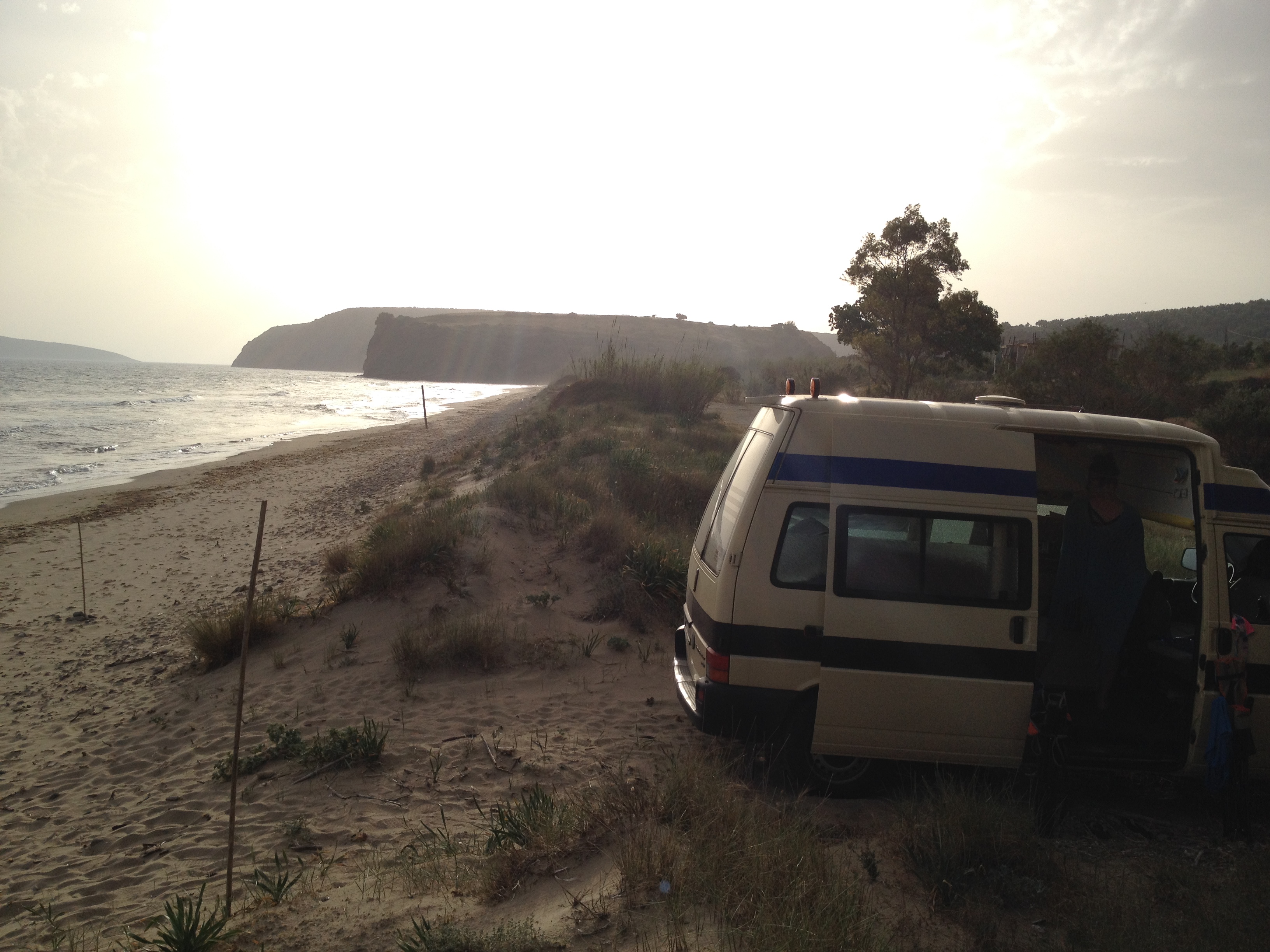
After a few days in Kalamata the tour continued with a stop at the Kazarma waterfalls, a day in the lovely town of Pylos and the Messenian coast where we had some spectacular campsites on deserted beaches, met some lovely people, and ate some great Greek food.
Off the south coast of the southwesternmost point of Messenia lie the Messenian Oinousses islands. The largest of these are Sapientza, Schiza and Venetiko. The small island Sphacteria closes off the bay of Pylos. All these islands are virtually uninhabited.
Methoni
(Greek: Μεθώνη, Italian: Modone, Venetian: Modon) is a village and a former municipality in Messenia, Peloponnese, Greece. Since the 2011 local government reform it is part of the municipality of Pylos-Nestoras, of which it is a municipal unit.[2] The municipal unit has an area of 97.202 km2.[3] Its name may be derived from Mothona, a mythical rock. It is located 11 km south of Pylos and 11 km west of Foinikounta. The municipal unit of Methoni includes the nearby villages of Grizokampos, Finikouda, Foiniki, Lachanada, Varakes, Kainourgio Chorio, Kamaria, Evangelismos and the Oinnoussai Islands. The islands are Sapientza, Schiza and Santa Marina; they form a natural protection for Methoni harbour. The town is also known by the Italian name Modone, which it was called by the Venetians.
Lefkada
Janni
Driving north we made a stop on the island of Lekada. On Kathisma beach we met up with Janni and Agelika who took us for lunch and then made it happen: flying over the most spectacular blue ever. That you so much for you friendship that day! And as usual, camping on the beach.
Lefkada measures 35 kilometres (22 miles) from north to south, and 15 kilometres (9 miles) from east to west. The area of the island is about 302 square kilometres (117 sq mi), the area of the municipality (including the islands Kalamos, Kastos and several smaller islets) is 333.58 km2(128.80 sq mi).[4] Its highest point is the mountain Stavrota, 1,158 metres (3,799 feet) above sea level,[5] situated in the middle of the island. The east coast section of the island has small resorts of Lygia, Nikiana and Perigiali, all north of Nidri, the largest resort on the island. It is set in a sheltered location with views across to Skorpios (formerly owned by Aristotle Onassis), Meganisi and other small islands, as well as the Greek mainland. The main coastal road from Lefkada to Vasiliki runs through the village, although a bypass has now been completed which skirts the village to the west. There are regular car ferries to Kefalonia, Ithaca and Meganissi.
20 kilometres (12 miles) south of Nidri is the resort of Vasiliki, a windsurfing center. There are ferries to Kefalonia and Ithaca from Vasiliki. South of Vasiliki is Cape Lefkada, where the Greek female poet Sappho allegedly leapt to her death from the 30 m high cliffs.
The famous beach of Porto Katsiki is located on Lefkada's west coast. Lefkada was attached to mainland Greece (see above about Homer's Ithaca being Lefkada). The Corinthians dug a trench in the 7th century BC on its isthmus.[6]
Kathisma beach
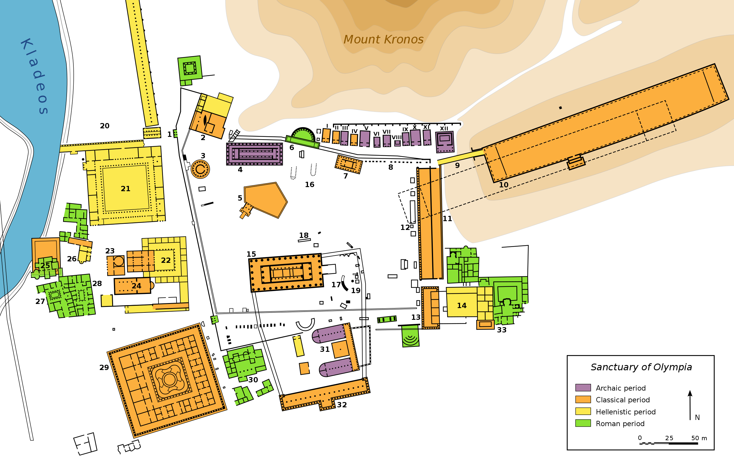
Olympia
Plan of Olympia
The Olympic flame of the modern-day Olympic Games is lit by reflection of sunlight in a parabolic mirror in front of the Temple of Hera and then transported by a torch to the place where the games are held. When the modern Olympics came to Athens in 2004, the men's and women's shot put competition was held at the restored Olympia stadium.[11][12]
The town has a train station and is the easternmost terminus of the line of Olympia-Pyrgos (Ilia). The train station with the freight yard to its west is located about 300 m east of the town centre. It is linked by GR-74, and the new road was opened in the 1980s; the next stretch N and NE of Olympia opened in 2005. The distance from Pyrgos is 20 km (12 mi), about 50 km (31 mi) SW of Lampeia, W of Tripoli and Arcadia and 4 km (2 mi) north of Krestena and N of Kyparissia and Messenia. The highway passes north of the ancient ruins. A reservoir is located 2 km (1 mi) southwest, damming up the Alfeios River. The area is hilly and mountainous; most of the area within Olympia is forested.
Panagiotis Kondylis, one of the most prominent modern Greek thinkers and philosophers, was born and raised in Olympia. When Pierre de Coubertin, the founder of the International Olympic Committee, died in 1937, a monument to him was erected at ancient Olympia. Emulating Evangelis Zappas, whose head is buried under a statue in front of the Zappeion, his heart was buried at the monument.[13]
The Metéora (Greek: Μετέωρα, pronounced [mɛˈtɛoɾɐ], literally "middle of the sky", "suspended in the air" or "in the heavens above" — etymologically related to meteorology) - is a formation of immense monolithic pillars and hills like huge rounded boulders which dominate the local area.
Meteora
One of the first things on landfall: Food
There are actually a few ski areas in Greece
Camping on the Kalamata beach/ LZ
Pyos
Near Methoni
One of the best – deserted beach camp sites
Kathisma, Camping on the beach
Kathisma Beach
Sunset over Meteora
Lonesome roads of Greece
Kastoria
Kastoria
Kastoria at night
Beautiful Greek Macedonia
Kastoria (Greek: Καστοριά, Kastoriá[kastoˈrʝa]) is a city in northern Greece in the region of West Macedonia. It is the capital of Kastoria regional unit. It is situated on a promontory on the western shore of Lake Orestiada, in a valley surrounded by limestone mountains. The town is known for its many Byzantine churches, Ottoman-era domestic architecture, fur clothing industry, and trout. Kastoria is an international centre of fur trade, which dominates the local economy. Indeed, (as mentioned above) the town was possibly named after one of the former staples of the trade – the European beaver (kastóri in Greek), now extinct in the area. Trading in mink fur now predominates and every year an international showcase of fur takes place in the city. Other industries include the sale and distribution of locally grown produce, particularly wheat, apples, wine and fish.


During the late Middle Ages, the town was the centre of the Barony of Kalavryta within the Frankish Principality of Achaea, until it was reconquered by the Byzantines in the 1270s. After that it remained under Byzantine control until the fall of the Despotate of the Morea to the Ottoman Turks in 1460. With the exception of a 30-year interlude of Venetian control, the town remained under Turkish rule until the outbreak of the Greek War of Independence in 1821, in whose early stages Kalavryta figures prominently: it was here that on 21 March 1821 the flag of the revolt was raised at the monastery of Agia Lavra by bishop Germanos III of Old Patras.
 During the late Middle Ages, the town was the centre of the Barony of Kalavryta within the Frankish Principality of Achaea, until it was reconquered by the Byzantines in the 1270s. After that it remained under Byzantine control until the fall of the Despotate of the Morea to the Ottoman Turks in 1460. With the exception of a 30-year interlude of Venetian control, the town remained under Turkish rule until the outbreak of the Greek War of Independence in 1821, in whose early stages Kalavryta figures prominently: it was here that on 21 March 1821 the flag of the revolt was raised at the monastery of Agia Lavra by bishop Germanos III of Old Patras.


One thought on “Gliderman IV – Greece”